
GUMPS -Ground Based Ultrawideband Multistatic Positioning System
By University Research Foundation
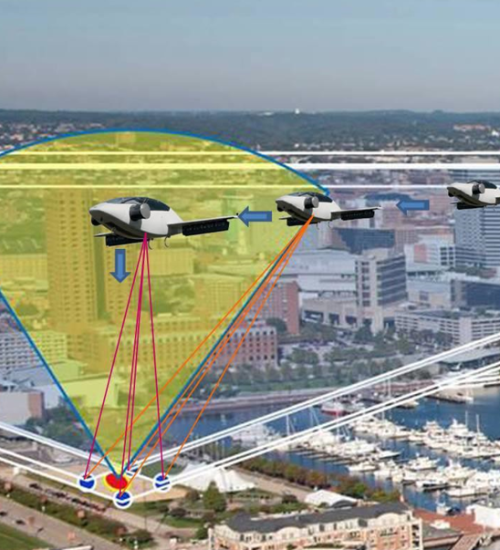

Overview
GUMPS is a radar-based ultrawideband positioning and conformance-monitoring system developed to support Urban Air Mobility (UAM) operations, especially in environments where GPS performance is unreliable or unavailable. Designed for both manned and unmanned VTOL aircraft, the system delivers precise vertical and near-vertical guidance needed for safe operations at Takeoff and Landing Areas (TOLAs). Initiated through a NASA SBIR Phase I feasibility study and now advanced into Phase II development, GUMPS brings robust sensing, vertical path tracking, and integrity monitoring to support the emerging UAM ecosystem.
Why GUMPS Is Needed
As air-taxi operations, VTOL aircraft, and UAM infrastructure expand, aircraft must maintain exceptionally accurate positioning throughout vertical approach and departure phases. Urban obstacles, RF congestion, adverse weather, and multipath effects can all degrade GPS integrity at the most critical moments of flight. GUMPS addresses this issue by providing a radar-based complement to GPS, offering localized conformance monitoring and corrective guidance that remains reliable even in challenging environments.
Key Capabilities
GUMPS combines GPS integrity assurance, vertical path tracking, and local traffic awareness into a single system. It continuously verifies whether GPS performance meets required navigation thresholds and provides supplemental guidance when it doesn’t. The system also monitors vertical velocity and descent profiles, helps sequence multiple aircraft around landing sites, and identifies non-cooperative targets such as drones or birds.
Core features include:
GPS conformance monitoring for position-integrity assurance
Corrective guidance logic for controlled approach/departure paths
Multi-platform sequencing and separation without relying solely on GPS
Non-cooperative target detection (e.g., drones, birds, unknown aircrafts)
Vertical velocity and path tracking for safer VTOL operations
Support for manned, controlled, and autonomous vehicles
Reliable performance in IMC and adverse weather conditions
Expeditionary, field-deployable configurations for emergency or remote landing sites
Advanced relative-attitude capability between aircraft and landing surfaces (e.g., shipboard or angled pads)
UTM / UAM Problem Statement
Urban Air Mobility requires highly accurate and robust positioning throughout vertical flight profiles. Aircraft operating near buildings, infrastructure, and in complex weather must maintain conformance with strict navigation performance requirements. Because GPS alone cannot always meet these demands, especially in dense or reflective environments, GUMPS supplies the ground-based sensing needed to ensure consistent, safe guidance into and out of landing zones.
Applications
Urban & Civil
GUMPS enables low-cost sensing for UAM vertiports and air-taxi sites by monitoring GPS performance, supporting vertical approach guidance, and providing additional separation tools for both cooperative and non-cooperative traffic. Its deployable variant can support emergency responders by creating instant landing guidance wherever permanent infrastructure is unavailable.
NASA Research
Within NASA’s UAM initiatives, GUMPS serves as a short-range radar solution capable of tracking UAV conformance, verifying GPS performance, and detecting small or large radar-cross-section targets. This allows for reliable operations of manned, remotely controlled, and autonomous vehicles even in degraded visibility or GPS-challenged conditions.
Defense & Expeditionary
For military and expeditionary operations, the system functions as a vertical-ILS-type capability suitable for brownout environments, dust-limited landings, and remote sites. Its auto-orienting configuration and rapid setup make it valuable for both temporary and permanent VTOL operations.
Program Phases
Phase I — Feasibility & Modeling
Phase I evaluated whether a ground-based ultrawideband multistatic architecture could provide accurate VTOL guidance and GPS integrity monitoring. Through simulation and analytical modeling, the team assessed sensor geometries, radar performance, and TOLA-specific approach/landing requirements. Results showed that a multistatic radar system could feasibly support UAM navigation in complex environments.
Phase II — Prototype Development & Testing
Phase II builds upon Phase I by designing, building, and testing a prototype system. The program incorporates COTS hardware where practical and integrates multistatic radar tracking, calibration logic, and processing algorithms. Testing progresses from controlled scenarios to operationally realistic environments, including situations involving non-cooperative targets, degraded GPS, and complex vertical approaches.
Program Summary
The GUMPS program began in 2020 under NASA SBIR sponsorship and continued development through 2023. Stakeholders include NASA Aeronautics/UAM programs, the Maryland Aviation Administration, University Research Foundation, MaXentric Technologies, and L3Harris. While early activity focused on simulations and modeling, Phase II includes hardware prototyping and field testing. The effort spans several URF service areas, including research and development, data and cloud systems, cybersecurity, and program management, with work centered on UAM airspace and VTOL landing zone operations.
Technical Note: Multipath Handling
At permanent installations, GUMPS can learn its environment over time. Because many periods involve no airborne traffic, the system can observe and characterize baseline multipath reflections. By applying adaptive filtering techniques, GUMPS distinguishes static reflectors from true airborne targets. This capability enhances accuracy and is a significant component of Phase II development.